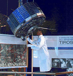
On April 1, 1960, the TIROS-1 satellite sent the first televised weather photographs of the Earth’s cloud cover and weather patterns to the giant 60-foot “Space Sentry” antenna at Fort Monmouth. The Television Infrared Observation Satellite Program (TIROS) was a joint government experiment to determine if satellites could be useful in the study of the Earth’s weather. Participants included NASA, the U.S. Army Signal Research and Development Lab at Fort Monmouth, RCA, the U.S. Weather Bureau, and the U.S. Naval Photographic Interpretation Center. At that time, the effectiveness of satellite observations was still unproven. The TIROS Program’s first priority was the development of a meteorological satellite information system, as weather forecasting was deemed the most promising application of space-based observations. TIROS proved extremely successful, providing the first accurate weather forecasts based on data gathered from space. TIROS began continuous coverage of the Earth’s weather in 1962 and was used by meteorologists worldwide. The program’s success with many instrument types and orbital configurations led to the development of more sophisticated meteorological observation satellites.
Sources:
The Television Infrared Observation Satellite Program (TIROS). (2016). NASA Science, May 22, 2016. Available: https://science.nasa.gov/missions/tiros/
Staff of the CECOM Life Cycle Management Historical Office. (2009). A Concise History of Fort Monmouth, New Jersey, and the U.S. Army CECOM Life Cycle Management Command. Available: http://www.fortmonmouthnj.com/wp-content/uploads/2014/12/Concise-History-of-Fort-Monmouth.pdf
Photograph of the TIROS-1 satellite taken at the Smithsonian National Air and Space Museum. Public Domain.


Leave a Reply